


Ardèche mars 2025 après midi

michel84
User

Length
37 km

Max alt
379 m

Uphill gradient
300 m
Km-Effort
42 km

Min alt
32 m

Downhill gradient
627 m
Boucle
No
Creation date :
2025-03-16 14:30:50.0
Updated on :
2025-03-16 17:31:08.892
2h59
Difficulty : Easy

FREE GPS app for hiking
 SityTrail
IGN / Geographical institutes
SityTrail Plus
The world is yours!
About
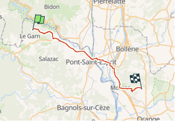
Trail 4x4 of 37 km to be discovered at Occitania, Gard, Le Garn. This trail is proposed by michel84.
Positioning
Country:
France
Region :
Occitania
Department/Province :
Gard
Municipality :
Le Garn
Location:
Unknown
Start:(Dec)
Start:(UTM)
618032 ; 4908331 (31T) N.
Comments